
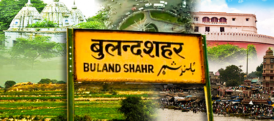
Bulandshahr is a district which is located in the state of Uttar Pradesh. Today we will learn all about the Bulandshahr district and its beauty through this post. In this post, we have covered most of the answers to all the questions related to the Bulandshahr district in your mind. Because we know that the Bulandshahr district is mainly connected with the roads of Meerut, Aligarh, Budayun, Gautam Buddha Nagar, and Ghaziabad districts, and in the eastern Ganges River and the west Yamuna The river makes its boundary.
Contents of this post
Where is the Bulandshahr situated?
Bulandshahr district is situated in Uttar Pradesh which is one of the largest states in India. The District of Bulandshahar is in the Meerut region of Utter Pradesh located between the Ganga and Yamuna rivers. This is situated between 28.4 0 south and 28.0 0 north latitude and between 77.0 0 and 78.0 0 longitudes.
Images and videos gallery for the Bulandshahr district?

Why is Bulandshahr famous?
Bulandshahr is famous worldwide because of the different profiles of Bulandshahr District such as RELIGIOUS PLACES, INDUSTRIAL DEVELOPMENTS, ADMINISTRATION, AGRICULTURE, AND GEOGRAPHICAL SITUATION OF DISTRICT. Religious places are the one main for the famous Bulandshahar.
Religious Places in Bulandshahr District.
- The first is potteries found in the Khurja region.
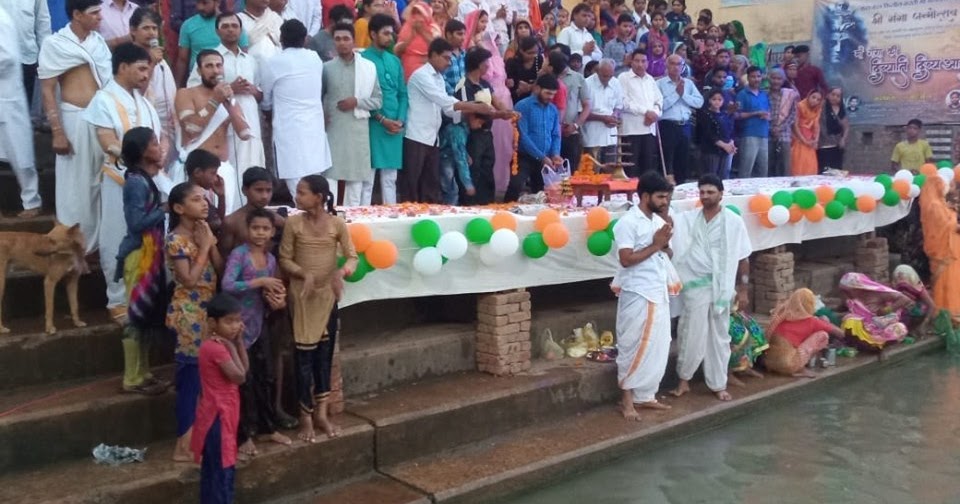
- And second, due to religious places, many Pilgrims from all around the world visit Bulandshahr to pay their respects at the Hanuman temple located on the bank of the holy river Ganga at Rajghat and the temple of Goddess Avantika and Lord Shiva at Ahar.
- Anoopshahr is another religious place in this area, that attracts a significant number of devotees to Bulandshahr.
- Chola is a small village famous for the Bibcol Chola Polio Vaccine factory.
- Karnavas holds great historical significance and is named after the great Mahabharata hero, Karna.
- Vallipura is a small scenic village located on the banks of a river.
- You can also visit Sikandrabad, which was built by Sikander Lodhi and has several ancient monuments. As with other cities and towns, Bulandshahr has its share of temples and religious monuments including the Belon temple in a place by the same name.
Industrial developments in Bulandshahr District
- In Bulandshahr There Is Panni Nagar Mill, Cooperative Sugar Mill Jahangirabad, Agauta Sugar & Chemicals Factory Are Established. There Is An Disttelary In Jahangirabad Sugar Mill.
- In Village, Chola has Located The Bibcol Factory For Manufacturing Polio Vaccines With Russian Collaboration.
- Bulandshahr Is An Industrially Developing District. Khurja Town Is A City Of Potteries, Where Tehre Are More Than Five Hundred Potteries. Potteries Of Khurja Have Earned Reputation At National & International Markets.
- Sikandrabad Industrial Area is another Such Region Where Several Big Industries Such as Kajaria Tiles, Orient Ceramics, Jp Gold Paints, Jenson & Nicholson, Rajdoot Paints, P.a.m Pharmaceuticals Etc Companies Are Located Here.
- And further Local Handicrafts And Other Artistic Things Are Made. Printing On Cotton Cloths Is Another Important Activity Done By Local Artisans.
Administration of Bulandshahr District
- Administratively the district is divided into seven subdivisions Dibai, Anoopshahr, Khurja, Shikarpur, Siyana, Bulandshahr, and Sikandrabad for development purposes
- And there are Sixteen development blocks Bulandshahr, Gulaothi, Lakhaowati, Shikarpur, Khurja, Pahasu, Arniya, Sikandrabad, Anoopshahr, Dibai, Danpur, Siyana, B.B.nagar, Jahagirabad, Uncha Gaon and Agauta blocks.
Agriculture in Bulandshahr District
- Bulandshahr Is An Important Agricultural District. It Has Undergone Green Revolution. Sugarcane, Wheat, Maize, And Potato Grows In Abundance.
- And State Government Has Declare Fruit Belt In Syana Area. Mango Archads Are Located In The Area.
- and more White Revolution In The Form Of Milk Production Is An Important Activity In The District.
Geography of Bulandshahr District
- The District is about 84 km in length and 62 km in breadth. The district is 237.44 meters above sea level.
- The District of Bulandshahar is in the Meerut region of Utter Pradesh located between the Ganga and Yamuna rivers.
- The geographical area of the district is 4353 sq km which is about 1.48 percent of the total Uttar Pradesh area. The urban area of the district is 122.8 sq km and the rural area is 4230.2 sq km. This district is near Delhi and is in the national capital region. The nuclear atomic power plant is located in the Narora town of the district. Near Sikandrabad town is located the national level satellite earth station. This is also an important grain-producing agriculture District.
- The river Ganga in the east separates this District from Moradabad and Badaun district and in the west river, Yamuna separates the district from Haryana state and Delhi. In the north of the district is Ghaziabad and in the southeast are the borders of Aligarh district.
How many Tehsil, Nagar Palika, and villages are there in Bulandshahar?
According to the government site,
7 Tehsils in Bulandshahr district
- Bulandshahr (Sadar)
- Sikandrabad
- Syana
- Anoopshahr
- Debai
- Shikarpur
- Khurja
9 Nagar Palika Parishads
1-Bulandshahr
2-Gulaothi
3-Sikandrabad
4-Khurja
5-Anoopshahr
6-Jahangirabad
7-Shikarpur
8-Syana
9-Debai
8 Nagar Panchayats
1-Aurangabad
2-Kakor
3-Pahasu
4-Chhatari
5-Bugrasi
6-Khanpur
7-B. B. Nagar
8-Naraura
the number of villages in Bulandshahr District
1246 which can be seen through the link.
And moreover, these are the subdivision and blocks in Bulandshahr
- Bulandshahr
- Agauta
- Gulaothi
- Lakhaoti
- Sikandrabad
- Khurja
- Arnia
- Anoopshahr
- Jhangirabad
- Shikarpur
- Pahasu
- Siyana
- Unchagaon
- B B Nagar
- Dibai
- Danpur
Is Bulandshahr rural or urban?
We can say Bulandshahr is a rural area because as per the 2011 census, 75.21 % population of Bulandshahar districts lives in rural areas of villages. The total Bulandshahar district population living in rural areas is 2,631,742 of which males and females are 1,390,490 and 1,241,252 respectively. And out of the total Bulandshahar population for the 2011 census, 24.79 percent lives in urban regions of the district. In total 867,429 people lives in urban areas of which males are 454,770 and females are 412,659.
| Bulandshahr | Population % | Numbers |
|---|---|---|
| In Urban | 24.79% | 867429 |
| In Rural | 75.21% | 2631742 |
| Total | 100% | 3499171 |
What is the history of Bulandshahr?
The history of Bulandshahr is too old, it begins even before 1200 B.C. This region is nearer to the capital of Pandavas – Indraprasth and Hastinapur. After of decline of Hastinapur, Ahar which is situated in the northeast of district Bulandshahr became an important place for Pandavas. With passes of time, the king Parma made a fort in this part of the region, and a king named Ahibaran laid the foundation of a tower called Baran(Bulandshahr). Since it was perched on a highland it came to be known as a high city which was translated into passion language as Bulandshahr. At present this is called by this name.
The ancient ruins found at places Bhatora Veerpur, Ghalibpur, etc. are symbolic of the antiquity of Bulandshahr. There are several other important places in the District from where statues of the medieval age and objects of ancient temples had been founded. Even today several historical and ancients objects such as coins, inscriptions, etc. are preserved in Lucknow State Museum.
According to the first war of independence in 1857, the first want of independence even Bulandshahr could not remain a lot of the popular explosion against the British rule. One message of the resolution was carried from Aligarh by Pandit Narayan Sharma on 10th May 1857 to Bulandshahr.
The first popular alarm of freedom struggle was sounded in the Bulandshahar district by the nationalist, brave. The Gurjaras of Dadri and the Sikandrabad area begin the destruction of inspection bungalows telegraph offices and government buildings as they were symbols of foreign rule. The government institutions were looted and burned to ashes.
What is the population of Bulandshahr?
The total Population of Bulandshahr as per the 2011 census is 3499171 and today approx. 3703295
What is the pin code of Bulandshahr?
The pin code of Bulandshahr district is 203001.
Is Bulandshahar a district?
Yes, it is a district located in the state of Uttar Pradesh of India.
How big is Bulandshahar?
The District is about 84 km in length and 62 km in breadth. The district is 237.44 meters above sea level.
In which zone is the Bulandshahar situated?
This is situated between 28.4 0 south and 28.0 0 north latitude and between 77.0 0 and 78.0 0 longitudes. The District is about 84 km in length and 62 km in breadth. The district is 237.44 meters above sea level.
How old is Bulandshahar?
it begins even before 1200 B.C. This region is nearer to the capital of Pandavas – Indraprasth and Hastinapur.
Map of Bulandshahar?
What is the distance between Bulandshahar and Delhi the capital of India?
As per the google map, The distance between Bulandshahar and Delhi is about 110 km to 124 km.
Chart of Bulandshahr numerical data
| Sl. No. | Description | Particulars |
| 1. | District Head Quarter | Bulandshahr |
| 2. | Tehsil/Sub-division | 7 Nos. |
| 3. | Police Station | 27 Nos. |
| 4. | Revenue Villages | 1246 Nos. |
| 5. | Block | 16 Nos. |
| 6. | Gram Panchayat | 951 Nos. |
| 7. | Nagar Palika/Nagar Panchayat | 17 Nos. |
| 8. | Parliamentary Constituency | 02 Nos. |
| 9. | Assembly Constituency | 07 Nos. |
| 10. | Area | 4353 Sq.K.M. |
| 11. | The population as per census 2011 | 3499171 Nos. |
| 12. | Density of Population | 788 Nos. |
What are the STD & Pincodes for Bulandshahr District?
| Tehsil Area | STD Code | PIN Code |
| Sikandrabad | 05735 | 203205 |
| Bulandshahr | 05732 | 203001 |
| Siyana | 05736 | 203412 |
| Anoopshahr | 05734 | 203390 |
| Dibai | 05734 | 203393 |
| Shikarpur | 05732 | 203395 |
| Khurja | 05738 | 203131 |
For more pin codes just check out the list of Bulandshahar pin codes
List of Hospitals of Bulandshahar District
Here is the list of Hospitals
- District homeopathic medical officer-Bulandshahr
- District leprosy officer-Bulandshahr
- Community Health Center Sikarpur-Sikarpur
- District Malaria Office-Bulandshahr
- District Tuberculosis Centers Bulandshahar-Bulandshahr
- Primary Health Center Dharpa-Khurja
- Primary Health Center Kaiser Kalan-Kaiser Kalan
- Community Health Siyana-Siyana
- Primary Health Center Malagarh-Malagarh
- Primary health center towli-Towli Bulandshahar
- Community Health Center Anoopshahr-Anoopshahr
- Community Health Center BB Nagar- B B Nagar
- CMO District Hospital-Civil Lines Bulandshahar
- Community Health Center Danpur-Danpur
- Community Health Center Dibai-Dibai
- SSMJ Hospital-Khurja
- Community Health Center Gulaothi-Gulaothi
- Community Health Center Jahangirabad-Jahangirabad
- Primary Health Center Unchagaon-Unchagaon
- Community Health Center Lakhaoti-Lakhaoti
- Community Health Center Muni-Muni Bulandshahar
- Rajkiya Joint Hospital-Sikandrabad
- Community Health Center Pahashu-Pahashu
- Primary Health Center, Vair-Vair
List of colleges/universities in Bulandshahr District
Here is the list of Colleges/Universities nearby Bulandshahar District
- Amar Singh College Lakkhawati Bulandshahr-Lakhawati Bulandshahar
- Arya Kanya Pathsala Snatkottar Mahayaya Khurja-Khurja
- Agarsen P G College Sikandrabad-Sikandrabad
- D A V College Bulandshahr-Bulandshahr
- Digamber P G College Dibai-Dibai
- DNPG College Gulaothi Bulandshahr-Gulaothi Bulandshahar
- Durja Prasad Baljeet Singh PG College Anoopshahr-Anoopshahr
- I P College Bulandshahr-Bulandshahar
- Jatan Swaroop P G College Sikandrabad-Sikandrabad
- N R E C Khurja-Khurja
- Rajkiya Mahavidhyalya B.B.Nagar
- Rajkiya Mahavidhyalya Jhangirabad
What is the list of helpline numbers in Bulandshahr District?
List of Helpline numbers
- CM Help Line: 1076
- Police Help Line: 112
- Fire: 101
- Medical Helpline: 108
- Women helpline: 1090
- Child Helpline: 1098
List of famous places to visit in Bulandshahr District?
Here is the list of interesting places to visit in the Bulandshahar District
- Rajghat – On the bank of Ganga, several temples are located here. the special temple of lord hanuman has 40 feet high statue of the monkey god.
- Karnavas – In the time of Mahabharat this was the place of great king Karna where he used to donate 50 kg of gold every day. Here is located the famous temple of goddess Kalyani.
- Ahar – On the bank of river Ganga is situated the famous temple of goddess Avantika & another one temple of a shiv.
- Belon –The famous temple of goddess belon is situated here.
Anoopshahr – An old town famous for pilgrimages situated on the river Ganga. several religious bathings and festivals are organized all the year-round. - Valipura –Scenic place in Bulandshahar on the local river van Chetna Kendra ( forest life consciousness) center is located here managed by the government forest department.
- Narora –World fame nuclear power plant is located here. a barrage is made on the river Ganga from where several canals originate. a good picnic spot and a big park are located here. it is 65 km from Bulandshahar.
- Khurja –17 Km. from Bulandshahar on gt road towards Aligarh known as a pottery town.
- Sikandrabad –The industrial area of district Bulandshahar is located here which is 18 km. from Bulandshahar towards Delhi on the main gt road. various textile, paint, pharmaceutical, cement, steel, and electronic industries are located here.
- Chola –Bibcol, the polio vaccine factory with Russian collaboration is situated here.
- Clock Tower– Clock Tower is in Central District Bulandshahr and is situated in Malka Park Bulandshahar.
- Kala Aam– The Kala Aam intersection has historic significance because the British used this place for public execution by hanging criminals. This place was probably called murder-A-Place and later the Kala Aam was distorted.
- Mud Fort– Kuchesar Fort, also known as the Mud Fort, is an 18th-century fort located in Kuchesar, India. Built in 1734, it is surrounded by 100 acres of mangrove forest. It is a heritage resort formed by the restoration of a section of Ajit Singh’s ancestral property, which was formerly a part of the princely state of Kuchesar.
Disclaimer- All information is provided from the source google search and Bulandshahar dot nic don in if you found any discrepancy or misinformation plz tell us by comment then will update it soon.